 Catalogue PIGMA
/Activités et Usages/Pêche et Aquaculture
Type of resources
Available actions
Topics
Keywords
Contact for the resource
Provided by
Years
Formats
Representation types
Update frequencies
status
Scale
Resolution
-
Mediterranean and Black Sea fisheries feature a great variety of target species, vessels and fishing gears and play an important socioeconomic role in the whole region. The mandate of the General Fisheries Commission for the Mediterranean (GFCM) is to ensure the sustainability of fisheries activities through the adoption of adequate management measures. The assessment of the size and state of the stocks exploited by fisheries is one of the pillars of modern management. The GFCM as the responsible Regional Fisheries Management Organisations (RFMO) of the Mediterranean and Black Sea has established permanent working groups on dermersal and small pelagic fish species where fisheries scientists perform their analysis and provide the best scientific advice to better manage fisheries and fish stocks. The groups, in cooperation with regional programs under the Regional Sea Conventions, set standards and guidelines for the collection, transmission and analysis of these data.
-
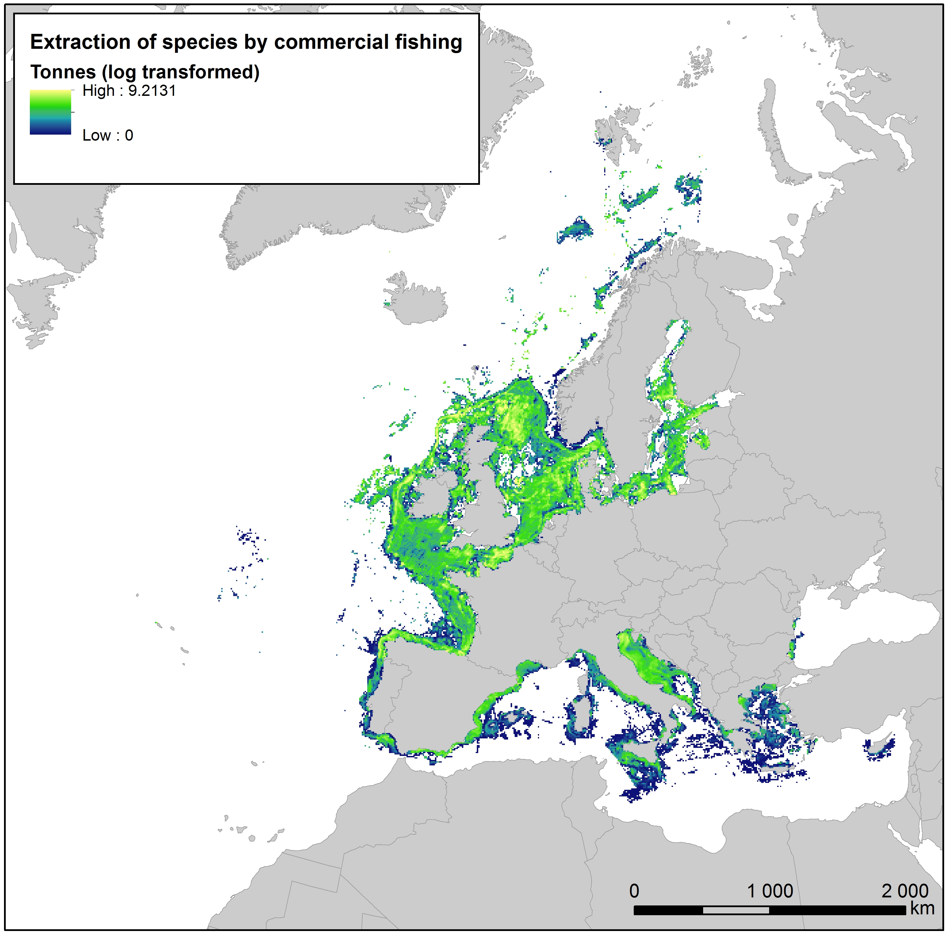
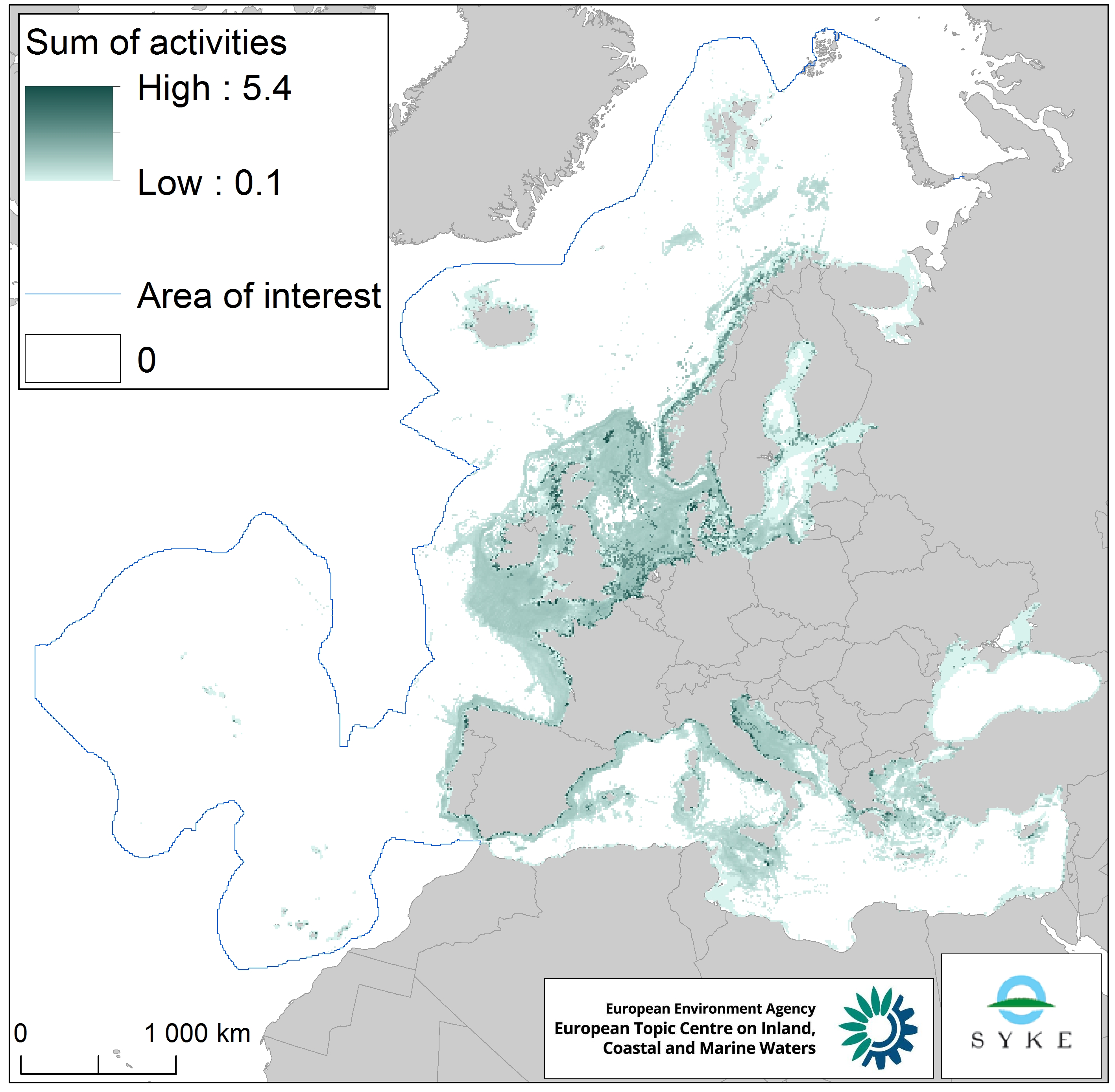
This raster dataset provides the estimation of the extracted tonnes of fish by commercial fishing per 10 km grid cell in the European seas. The dataset has been derived from the combination of demersal and pelagic fishing data, together with fish landings data (2011-2016) from the European Commission’s Joint Research Centre - Independent experts of the Scientific, Technical and Economic Committee for Fisheries (JRC STECF). The temporal extent varies between the data sources. The cell values have been transformed to a logarithmic scale (ln1). This dataset has been prepared for the calculation of the combined effect index, produced for the ETC/ICM Report 4/2019 "Multiple pressures and their combined effects in Europe's seas" available on: https://www.eionet.europa.eu/etcs/etc-icm/etc-icm-report-4-2019-multiple-pressures-and-their-combined-effects-in-europes-seas-1.
-

The raster dataset represents fishing intensity (kilowatt per fishing hour) by pelagic towed gears in the European seas. The dataset has been derived from Automatic Identification System (AIS) based pelagic fishing intensity data received from the European Commission’s Joint Research Centre - Independent experts of the Scientific, Technical and Economic Committee for Fisheries (JRC STECF), as well as from Vessel Monitoring System (VMS) and logbook based pelagic fishing effort data from HELCOM Commission. The temporal extent varies between the data sources (between 2013 and 2015). The dataset has been transformed to a logarithmic scale (ln1). This dataset has been prepared for the calculation of the combined effect index, produced for the ETC/ICM Report 4/2019 "Multiple pressures and their combined effects in Europe's seas" available on: https://www.eionet.europa.eu/etcs/etc-icm/etc-icm-report-4-2019-multiple-pressures-and-their-combined-effects-in-europes-seas-1.
-
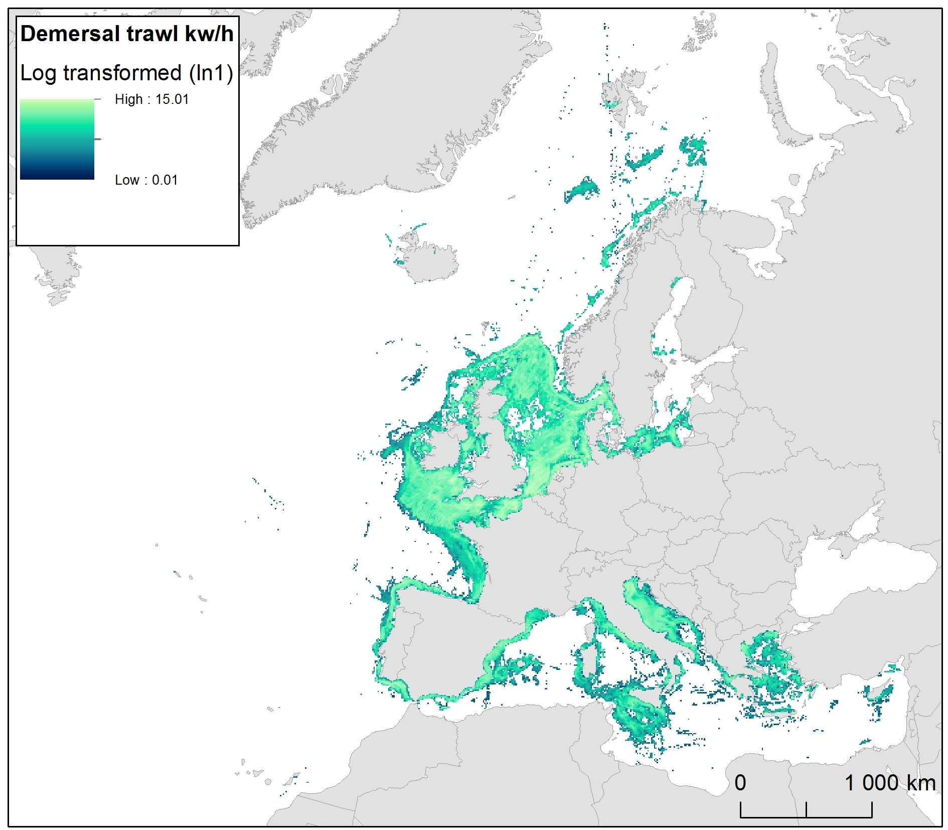
The raster dataset represents bycatch fishing intensity (kilowatt per fishing hour) from bottom touching mobile gears in the European seas. The dataset has been derived from Automatic Identification System (AIS) based demersal fishing intensity data received from the European Commission’s Joint Research Centre - Independent experts of the Scientific, Technical and Economic Committee for Fisheries (JRC STECF) as well as Vessel Monitoring System (VMS) and logbook based demersal fishing intensity data downloaded from from OSPAR and HELCOM Commissions. The temporal extent varies between the data sources (between 2014 and 2017). OSPAR and HELCOM data superseded the JRC STECF data where they overlapped spatially. The cell values have been transformed into a logarithmic scale (ln1). This dataset has been prepared for the calculation of the combined effect index, produced for the ETC/ICM Report 4/2019 "Multiple pressures and their combined effects in Europe's seas" available on: https://www.eionet.europa.eu/etcs/etc-icm/etc-icm-report-4-2019-multiple-pressures-and-their-combined-effects-in-europes-seas-1.
-

The dataset presents the potential combined effects of sea-based pressures on marine species and habitats estimated using the method for assessment of cumulative effects, for the entire suite of pressures and a selected set of marine species groups and habitats by an index (Halpern et al. 2008). The spatial assessment of combined effects of multiple pressures informs of the risks of human activities on the marine ecosystem health. The methodology builds on the spatial layers of pressures and ecosystem components and on an estimate of ecosystem sensitivity through an expert questionnaire. The raster dataset consists of a division of the Europe's seas in 10km and 100 km grid cells, which values represents the combined effects index values for pressures caused by sea-based human activities. The relative values indicate areas where the pressures potentially affect the marine ecosystem. This dataset underpins the findings and cartographic representations published in the report "Marine Messages" (EEA, 2020).
-
Cartographie des écluses à poissons au XXème siècle de l'Île d'Oléron et des écluses ayant existé d'après consultation de sources historiques.
-
Cartographie actuelle des écluses à poissons présentes sur l'Île de Ré et des écluses ayant existé d'après consultation de sources historiques.
-

Rapport présentant les chiffres clés sur la production, les premières ventes, le commerce extérieur français et la consommation de produits aquatiques. Le nombre d'entreprises, d'emplois, ainsi que le chiffre d'affaire du secteur du mareyage, y figurent notamment. Le rapport présente les dernières données disponibles au 31 mars 2021.
-
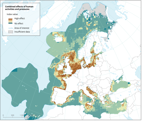
The dataset presents the potential combined effects of human activities and pressures on marine species and habitats estimated using the method for assessment of cumulative effects, for the entire suite of pressures and a selected set of marine species groups and habitats by an index (Halpern et al. 2008). The spatial assessment of combined effects of multiple pressures informs of the risks of human activities on the marine ecosystem health. The methodology builds on the spatial layers of pressures and ecosystem components and on an estimate of ecosystem sensitivity through an expert questionnaire. The raster dataset consists of a division of the Europe's seas in 10km and 100 km grid cells, which values represents the combined effects index values for pressures caused by human activities. The relative values indicate areas where the pressures potentially affect the marine ecosystem. This dataset underpins the findings and cartographic representations published in the report "Marine Messages" (EEA, 2020).
-
This raster dataset represents physical disturbance to the seabed in the European seas. Several human activities disturb the seabed either directly or indirectly. Alteration of benthic living conditions as a result of increased sedimentation or attenuation of light penetration, abrasion of the seabed and exploitation of benthic biota, temporarily disturb the benthic habitat quality. The dataset is an aggregation of several different human activities that cause physical disturbance to the seabed: aquaculture, demersal fishing, dredging and dumping of dredged material, oil and gas rigs, offshore installations, ports, sand and gravel extraction, shellfish mariculture, shipping in shallow waters and windfarms. The resulting dataset is a raster (10km grid cell) derived from EMODnet, MED-IAMER, JRC-STECF, OSPAR, HELCOM and 4C Offshore datasets, and with reference temporal coverage from 2012 to 2017. This dataset has been prepared for the calculation of the combined effect index, produced for the ETC/ICM Report 4/2019 "Multiple pressures and their combined effects in Europe's seas" available on: https://www.eionet.europa.eu/etcs/etc-icm/etc-icm-report-4-2019-multiple-pressures-and-their-combined-effects-in-europes-seas-1.